| Switzerland of Africa: Part Four Guinea's Atlantic Coast and the Slave Route by Muguette Goufrani

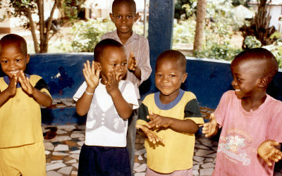
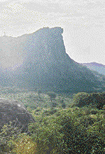
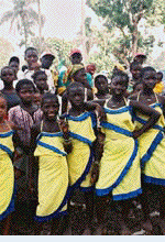
The above photograph was taken during our escorted tour of Guinea's "Slave Route" several hours drive along the Atlantic Coast from the capital city of Conakry. Seeing this group of happy youngsters is like a salute to freedom. The Slave Route bus tour was provided courtesy of the Ministry of Tourism and it preceded my longer journey to the north by a few days. The young Guineans in the above scene are posing beside the barrel of a huge European cannon, a rusty relic left over from that dark and turbulent era in West Africa's history. On the way to Boké, we made a river crossing by ferry and later drove beside a stretch of beautiful, pristine beaches that are said to be among the finest on the Gulf of Guinea, which fronts on several neighboring West African countries. On many weekends expatriate workers from the nearby bauxite mines travel to the beaches for recreation. To them, it's like having a private resort that matches many swank club venues I've seen on this continent and others. The former slave fort at Boké village is now an historic tourist site and museum, which features abandoned holding cells, underground passages and hideouts areas along the river's estuary where slaves were kept from general view. During our stay at the village, several of us had an opportunity to spend time with a family whose ancestors were slave traders from South Carolina. Many Guineans from this area were transported to America to help develop Carolina's rice growing industry. The lay of the land: I will provide more details the Slave Route in the next edition of Africa Travel Magazine, and elaborate on other facets of our congress activities and travels in Guinea. We plan to organize tours from Canada and the USA to Guinea starting in 2003, and this Slave Route experience will be high on our agenda. For an overview of this fascinating country in terms of geography and scenic attractions, the following information has been provided by the Ministry of Tourism. There are 4 distinct areas designated by relief, climate, flora and fauna, which are reflected in Guinea's history and traditions. Low Guinea: Stretching along the Atlantic Ocean shoreline, and the mountains of Fouta Djalon, plus lush vegetation with mangrove swamps and coconut palms. Offshore Islands: Idyllic scenery with miles of pristine, silver sand beaches and rivers with broad estuaries. Central Guinea: Large mountains and high plateaus, plus a temperate climate has earned the area the title "Switzerland of Africa". The highest peaks are Mount Loura in Mali (1515 m) and Mount Tinka in Dalaba (1425m). They call it the Water Tower of Western Africa because many rivers take their origin (River Gambie, Senegal, Niger, etc.) from it. These rivers and churning rapids, hurtling down the mountains create beautiful waterfalls. High Guinea: Plateaus with vegetation and wooded Savannah with a dry climate. The River Niger and its many tributaries enrich the soil, making the area is particularly appealing. Forestry of Guinea. The subequatorial zone is the domain of dense forests with giant trees and lush groves. Mount Nimba (1752m) doesn't attract visitors for its rich copper ore alone, there is abundant wildlife and rare flora. That's why it is ranked as a Unesco World Heritage Tourism Landmark. Loos Islands. Located near Conakry is an archipelago, the key islands being Kassa, Room and Fotoba. There is also Tortoise Island (where giant tortoises are protected), Snake and Kid Islands. With easy access by boat, these islands offer beautiful white sand beaches for relaxation and nautical sports. The Dog that Smokes (Bondabom): Only 42 km from Conakry, on the crest of Mount Kakoulima, is a phenomenal image on the rock face; an enormous silhouette of a dog's head. A sculptor's hands could not do better, and it's even more striking when there's a thick fog, and a wispy smoke seems to come from the animal's mouth. Beach at Bel Air. 225 km from Conakry in the Boffa area, Bel Air beach provides 7 km of white and silver sand. Gentle sea breezes and luxuriant vegetation make it a paradise. Slave Road . Located along the coast (Conakry, Forecariah, Dubreka, Boffa and Boke) it's a grim reminder of the Slave Trade. A joint project of UNESCO and OMT, access is partly by asphalt road, local trails or by the river road. Bride Veil. A marvel of nature, 146 km from Conakry and 13 km from Kindia on the Mamou road are two waterfalls that create a veil of exceptional beauty and whiteness. The name "Bride Veil" attests to its natural charm. There's a stage for cultural dancing, 10 bungalows, a restaurant and bar. Dalaba Mountain Resort. A key tourism site since the Colonial period, Dalaba is nestled in the Foutana highlands, among lush vegetation. It's a charming community, with freshly scented air and an average temperature of 10 degrees c. The structure built by Colonial authorities and businessmen is still standing. The Lady of Mali. On Mount Loura at 1500 m, a woman of remarkable beauty defies the ages. Shaped into the rock by the wind erosion with all her anatomy visible, "the lady of Mali" is nature's masterpiece. Mali town is 588 km from Conakry, and easy to access. Source of the Niger: Located 562 km from Conakry at Rubiko in Faranah is the source of one of Africa's great rivers. While it's mystery has attracted many historical expeditions, it is easy to reach by a mostly asphalt road. Seredou Post. This area has its own micro-climate, and a commanding view. Located at 1200 m altitude, 40 km from Macenta by asphalt road. Nimba Road: A UNESCO World Heritage site, located 1040 km from Conakry and 17 km from Kola, with access from N'Zerekore. At 1752 altitude is a forested area with rare wildlife (buffalo frogs and chimpanzee families) at Bossou. Carafir: Site of a hydroelectric dam (75 mw), supplying electrical energy to the Low and Medium Guinea. Access is by the National Road #1 and a quality asphalt road. The dam site is famous for its wildlife and flora. The lake view is especially beautiful, and its waters provide an opportunity for great freshwater fishing. Badiar National Park. A natural extension of Niokolokoba on the Senegalese border, the (38.200 ha) park is located in Koundara Prefecture, and wildlife is abundant in this area. Alcatraz Island. A rocky island, Northwest of Boke and 300 km from Conakry, it contains one of the greatest concentrations of sea birds in West Africa. High Niger National Park. The area abounds with game and is located in Guinea East, covering a 4000 km2 area in the Prefectures of Faranah, Dabola and Kouroussa.
Footnotes
Guinea is on the Atlantic Coast, bordering Liberia and Sierra Leone. In this section travelers will find a brief visual sample of Guinea's beaches, attractions, shops, restaurants and hotel facilities, plus local tour operators to be featured in our Africa Travel Magazine. Some items will also be available in French thanks to our Associate Editor Muguette Goufrani, whose travel agency career began in North and West Africa's French speaking countries. Since Guinea is a developing West African country, travelers should make Conakry hotel reservations in advance. GUINEA COUNTRY PROFILE: U.S. Embassy: B.P. 603, Conakry, Guinea
tel.: (224) 41-15-20/21/23, fax: (224) 41-15-22.
Geography and Environment: On Atlantic Coast Generally flat coastal plain, hilly to mountainous interior. Generally hot and humid; monsoonal-type rainy season (June to November) with southwesterly winds; dry season (December to May) with northeasterly harmattan winds Environment issues: Deforestation; inadequate supplies of potable water; decertification; soil contamination and erosion; overfishing, overpopulation in forest region. International agreements: Biodiversity, Climate Change, Decertification, Endangered Species, Hazardous Wastes, Law of the Sea, Ozone Layer Protection, Wetlands. Population: Total: 7,466,200 (July 2000 est.).
Languages: French (official), each ethnic group has its own language Religions: Muslim 85%, Christian 8%, indigenous beliefs 7%
Ethnic groups: Peuhl 40%, Malinke 30%, Soussou 20%, smaller ethnic groups 10%
National holiday: Anniversary of the Second Republic, 3 April (1984)
Legal system: based on French civil law system, customary law, and decree; legal codes currently being revised; has not accepted compulsory ICJ jurisdiction. Economy: Currency: 1 Guinean franc (FG) = 100 centimes
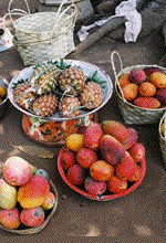
Exchange rates: Guinean francs (FG) per US$1 - 1,292.5 Guinea possesses major mineral, hydropower, and agricultural resources. The agricultural sector employs 80% of the work force. Guinea possesses over 25% of the world's bauxite reserves and is the second largest bauxite producer. The mining sector accounted for about 75% of exports in 1998. Industries: bauxite, gold, diamonds; alumina refining; light manufacturing and agricultural processing industries. Exports: bauxite, alumina, gold, diamonds, coffee, fish, agricultural products. GDP : agriculture: 24%, industry: 31%, services: 45%. Electricity - production by source: fossil fuel: 63.55%, hydro: 36.45% Agriculture - products: rice, coffee, pineapples, palm kernels, cassava (tapioca), bananas, sweet potatoes; cattle, sheep, goats; timber Transportation: Airports - with paved runways: 5
Domestic airlines offer services to most interior cities, often to rudimentary dirt landing strips
Railways: total: 1,086 km (includes 662 km in common carrier service from Kankan to Conakry)
Highways paved: 5,033 km
Ports and harbors: Boke, Conakry, Kamsar
Waterways: 1,295 km navigable by shallow-draft native craft
Television broadcast stations: 6 • Guinea's major ethnic group the Malinke also reside in parts of Mali, Cote d'Ivoire and Senegal, and at an earlier time ruled one West Africa's great empires. Malinke are also known to have originated the best kora musicians in West Africa. The kora is a unique and popular musical instrument in the area. For details on the amazing kora- visit this informative website: http://www.coraconnection.com/ ENTRY REQUIREMENTS: A passport and visa are required. There is an airport departure tax. Travelers should obtain the latest information and details from the Embassy of the Republic of Guinea, 2112 Leroy Street, N.W., Washington, D.C. 20008, telephone (202) 483-9420. Overseas inquiries should be made to the nearest Guinean Embassy or Consulate. CURRENCY REGULATIONS: All travelers to Guinea are prohibited from having more than 5,000 Guinean francs (about four US dollars) in their possession when they leave the country. Western Union has an office off the Avenue of the Republic in downtown Conakry. Money transfers have worked successfully. Credit cards are rarely accepted, except at the two major hotels in Conakry. Credit card cash advances are not available. Inter-bank fund transfers are possible at the "BICIGUI", a local bank, but can be difficult and expensive. TELEPHONES: Several cellular phone services are available. A number of public phones operate by locally purchased phone cards. Telephones are available in Conakry and in other major towns and hotels. However, while privatization has improved the communication system, disruptions in telephone service are common. Tourism Marketing: As a team, Guinea's Ministry of Tourism, Hotels and Handicraft, supported by its National Tourism Office, the Promotion and Development Office of Handicrafts, and the Professionals Federation, is staging a strong, combined effort. Their project is the development and promotion of the rich natural and cultural heritage that visitors to Guinea are invited to discover. Photo Credits: Muguette Goufrani / Robert Eilets / Guinea Ministry of Tourism 
Continued on next page->
Photo Credits: Muguette Goufrani / Robert Eilets / Guinea Ministry of Tourism |